Our Flying Site:
The Chambersburg ModelAirs flying site is located just south of town behind the Franklin Learning Center school. Use the map above to create directions to the field from your location.

Click here for a printable version of our flying field map
We have a rolled grass strip that is approx. 60’x600′ and is north/south oriented. Approach is unhindered from either end of the runway but there are power lines to the east. If you have any questions or comments, or would like a more detailed picture of any areas, please feel free to email us and let us know what you would like.
This view of the field is taken from the south end of the pit area looking northeast.

This view of the field is taken from the south end of the runway looking north. The tennis courts hug the north end of the runway but so far have claimed few victims. A porta-potty is available during the summer flying season next to the tennis courts.

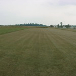
This view of the field is taken from the north end of the runway looking south.
This view of the field is taken from the north end of the pit area looking south.

Picture of our frequency board. When flying with the older frequency receivers (pre- 2.4 Ghz), each member is required to simply place clothes pins on their channels used. Pins have name and channel information written in.

The school was gracious enough to allow us to place an equipment shed on the grounds. Mowing and maintenance equipment is stored onsite.

We also have use of a small pavilion and playground area at the school. This comes in handy for club picnics.